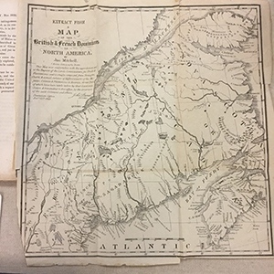
“Extract from a Map of the British and French Dominions in North America, 1755” in U.S. Congress, Senate’s Report and Resolves in Relation to the North-Eastern Boundary. 1838.
The map included in this Senate report documents the colonial survey completed by the British Board of Trade in 1755 illustrating the disputed territory. The disputed territory comprehends nearly seven millions of acres – the joint property of Massachusetts and Maine. It contains 10,705 square miles, being 2,905 square miles, or 1,859,200 acres more than the entire territory of this Commonwealth. A committee of our own Legislature, who visited these lands in 1835, say of the Allagash country which lies within the disputed territory, ‘there can be no doubt, but that this is the best timbered tract in Maine, if not in the world.” Again, they say, ‘this timber is indispensable in the finish, and ornamental work of all our dwellings; and to this territory must nearly all the Atlantic towns and cities look for a supply…
